Hiking is starting to become one of my favorite sport. I like it because it brings me austerity, challenge, and a feeling of being "on edge." Also, unlike other sports I do, hiking gives me the opportunity to travel. It allows me to explore, appreciate, and reconnect with the marvel that is our nature. Away from the city's busyness into a terrain of untouched lands, innocent sights, and where time seems to pass more slowly than usual.


My recent travel brought me to Nasugbu, Batangas. I went to hike Mt. Batulao. This mountain is rated 4/9 in difficulty and involves an open trail, rolling slopes, and a slight rock climb before the summit. It's a mountain for beginners, perfect because at the time, I wanted to take my time to walk, to take pictures, and to just appreciate the experience of being on a mountain.
About Mt. Batulao
Mt. Batulao is located in the border of Nasugbu, Batangas and Tagaytay city. Its name is derived from a play of the Tagalog word, Bato sa ilaw, which describes how the mountain glow orange as it is bathed in the morning sun. It is easily accessible and it is a popular hike and camp site for people south of Metro Manila. Hikers flock this mountain especially on weekends. As such it is always expected to host crowds along its trail and summit.
.jpg)
Its 4/9 difficulty rating makes it an ideal mountain for first timers or to those who simply want a weekend trek. Its 811 MASL summit takes 2-4 hours to get to. There are a few steep segments in its trails but in general, hiking Mt. Batulao is not that demanding.
 |
| View from the old trail |
As I've mentioned, Mt. Batulao has an open trail that gives a panoramic view of Nasugbu and Cavite. Other mountains can also be seen from its vantage point namely, Mt. Talamitam and Mt. Maculod in Cuenca, Batangas. There are also two trails to choose from: the new trail and the old trail. The new trail is the shorter route. The old trail is the one that will take 2-4 hours but it has the better view. I went with the latter for my hike.
The hike
A turn into KC hillcrest hotel and golf club along Tagaytay-Nasugbu highway led us straight into a barangay situated before Mt. Batulao trail's entrance. There were about 15 of us but we were grouped into 3, and became led by 1 tour guide each. We were oriented on the do's and don't while on the hike: no littering, no destroying of faunas, being careful on steep segments etc. We are also reminded of the difficulty of the terrain and what to expect as the ascent go steeper. We are given time to prepare everything we need: flashlights, repellants, foods, water etc. Then after a few minutes we started our trek at 5 am, just before dawn.
 |
| The muddy trail at noon |
The first part of the hike involves walking through a muddy terrain that gets steeper as we go along. We are still passing some of the barangay's houses and we were greeted by locals getting ready for their day. Horses were also a common sight in this early part of the hike. Our walk into the muddy trail went for at least an hour up until the residential areas were no longer in sight.
Our path eventually narrowed. The trail also became steeper. I could tell that we are starting to gain elevation from the view that was starting to unravel before us. Daybreak came and the trail became illuminated by an orange hue, revealing the peak that we are aiming for, together with the picturesque plains of Nasugbu.
 |
| One of Mt. Batulao's peak illuminated by sunrise. |
Mt. Batulao has 12 peaks. These peaks can be considered summits on their own, the twelfth being the highest and the true summit of them all. Each of them also serve as rest stops and sites for photo opportunities.
 |
| A Mt. Batulao peak marker |
We still have 11 peaks to go through so we wasted no time and continued to trek. We passed by rolling slopes, hills, and fellow hikers along the way. We also spotted more locals who are either selling refreshment at the peaks or on their way down the mountain.
As we ascend further, the neighboring towns of Nasugbu came to view. In sight are Tagaytay, Lemery, and Calaca. Also we can now see the nearby mountain, Mt. Talamitam, at this point.
.jpg) |
| Mt. Talamitam as seen in Mt. Batulao's 3rd peak. |
In this part of our hike, I slowed my pace down to appreciate nature. We are still walking but I can't help gazing far and wide, in front and below the cliffs, to take in more of my surroundings. It became sort of a meditation for me as I ground myself back into the simple joy of being outdoors.

Perhaps I felt this because it has been a long time since I was out on a mountain and that I have been accustomed to staying in the city these past few years that breaking my routines gave me a chance to feel rejuvenated.

Our path soon became paved with boulders and rocks but we passed by the 2nd and 3rd peaks without difficulty. We also came across the designated campsites where some hikers stayed overnight. Our tour guide shared that they are hikers who climb without guides for the sole purpose of camping.

We passed the 4th, 5th, 6th and 7th peak. The 8th peak, also called Diana's peak, offered another view of the Nasugbu landscape but on a higher elevation.
 |
| A photo at Diana's peak |
It was now around 6:30 AM and everything was in full view. We can see Batulao's peak more vividly at this point. Our tour guide advised us that the ascent will get steeper as we near the summit.
 |
| View of Mt. Batulao's summit from the rock cliffs |
Peaks 9, 10, and 11 were behind us. We scaled through rock cliffs but there are ropes help get across some steep paths. It required us a 70-90 degrees assault to conquer this last segment before the summit.
At Mt. Batulao's peak
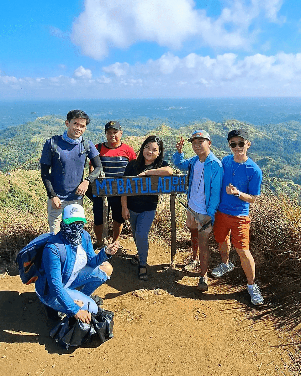
We reached the summit 2 hours and 30 minutes from when we started. There are crowds at the peak but not so much as to ruin the experience. There's also another stall in here that sells food and refreshments.
What I like about Mt. Batulao's peak is that it is a flat surface, unlike for example, in Mt. Marami where hikers need to be cautious atop its rocky summit. Mt. Batulao's summit is a mixture of soil, rock, basalt and andesite, patched by Cogon grass and Kans grass.

The clear sky illuminated everything in sight: Mt. Talamitam, the Taal lake, Balayan bay, and parts of Cavite and Batangas. It was a new sight for me to behold for sure. One to be kept in my memory alongside the usual elevated view from the nearby Tagaytay.

We spent an hour resting and taking photos. At around 8:30 am, we departed Mt. Batulao's summit.
End of the hike
We descended amidst the heat of early noon. As with every other hike, I find the descent to be more challenging. At the time of our descent is when other hikers start to crowd the trail and the summit. As such, we had delays going through some steep segments as it allows only one person to pass at a time.
After clearing the rock sections below the summit, we were back into the rolling slopes segments where we walked for another 2 hours with ease all the way to our jump off point. We finished the hike just before 11 AM and had a side trip to Tagaytay to have lunch before heading home.
* * *
Hike summary
Mt. Batulao, as one of the accessible mountains near Metro Manila, should be part of any checklist of both beginners and experienced hikers. Its beautiful open trails and picturesque views of Batangas is worth the 2-4 hours trek into its summit.
.jpg) |
| Mt. Batulao's silhouette as seen in Batulao Forest. |
Seeing its multiple peaks turn orange during sunrise was a memorable experience, no wonder many hikers return to this mountain many times a year. I just hope the crowd will continue to be regulated though as it, I think, is the single thing that could ruin the beautiful experience of hiking Mt. Batulao.

Overall, our hike was a pleasant, growing, and awe-inducing experience. It helped me reconnect with myself through challenge, and to nature through it's appreciation.

Comments
Post a Comment