

Our journey in the north continues as we explore this natural side of Ilocos. Rejuvenated from our long drive the day before, we are now set to get back on the road and experience the nature wonders of the north.
Our first destination is one not far from Blue Lagoon: the enchanting Bantay-Abot Cave.
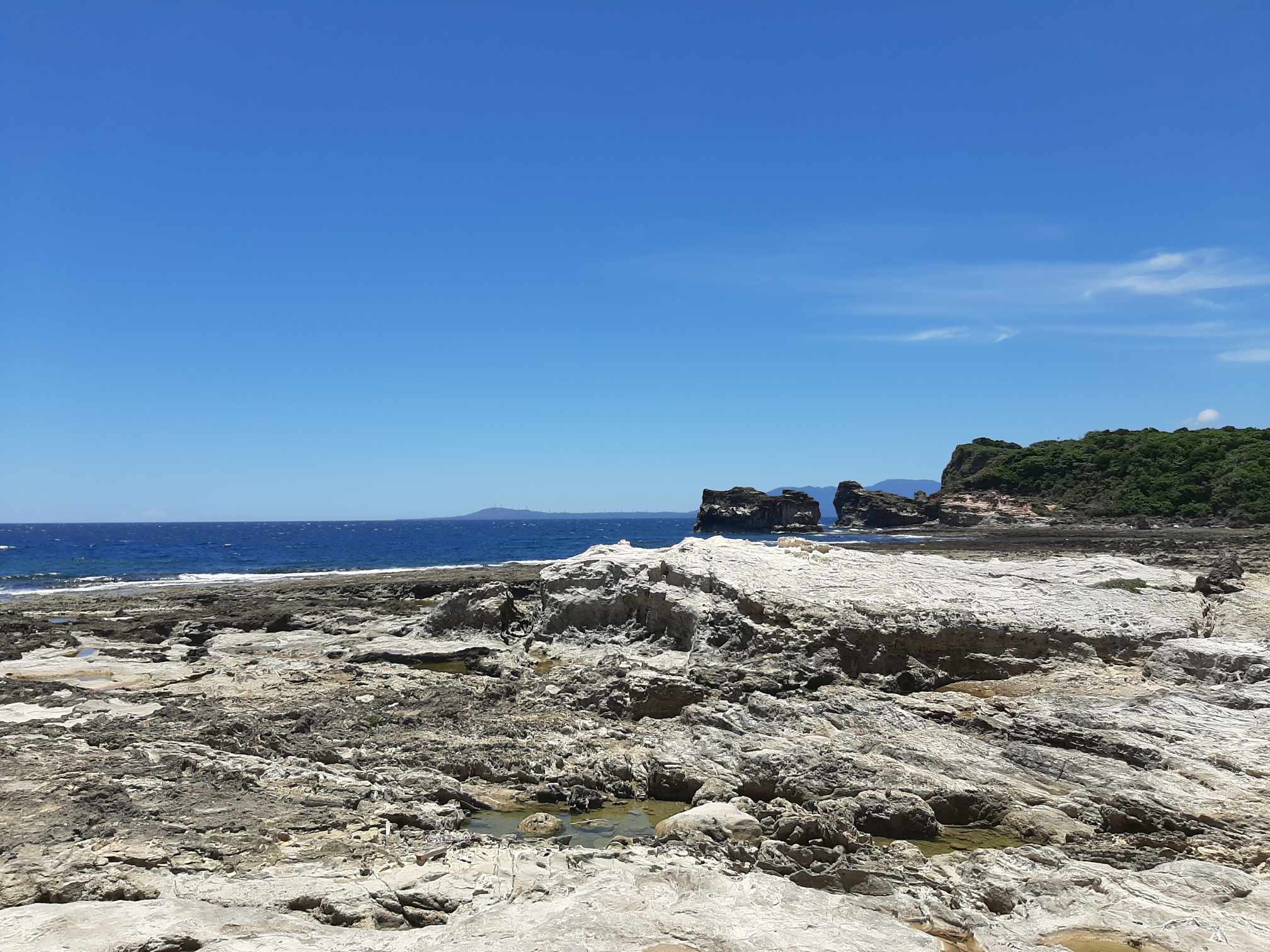
* * *

Bantay-Abot Cave is a rock formation on the shores of Balaoi, Ilocos Norte. It isn't really a cave per se; it is a holed hill that looks like a mass of rocks with an unusual hole in it's center. The hole simply ends up on the other side of the shore.
 |
Walking through slippery rocks, we took time to take our photos while exploring the hill's vicinity.

Crowds don't gather much at Bantay-Abot cave. And there's no entrance fee either. Visiting it is as open as strolling down a beach. It's a natural site that is easily accessible for tourists and locals alike.
* * *
From Bantay-Abot cave, we now made our way into the neighboring municipality of Bangui, where the famous windfarm is located.

* * *
Whenever I think of Ilocos, a picture of windmills lined up on a shore always comes to mind. I'm sure that it's the same for many people, too. But off from our imagination, here we are now, on the shores of Bangui, taking a closer look at the real thing.

The view is just how I imagined it: The breeze of the ocean, the sprawling sand and a view of the towering windmills in the distance-it is understandable why the windfarm attracts tourists. The neatly arranged windmills is pleasing to look at, plus, and most importantly, it is a way of harnessing clean energy.
Overall, the windmills scattered around Ilocos contributes up to 40% of the region's electricity needs.

Unknown to most of us, the windmills in Ilocos are owned and operated by different companies. This one in Bangui, which opened in 2005, is previously owned by Northwind development corporation but is now managed by the Ayala Energy group.

The windmills poses no pollutions-no danger-and no disturbances to the locals, and to the environment in general. They not only functions as sources of energy, but also as an economic booster, promoting both the tourism of Bangui and the opportunities for livelihood of the municipality's locals.
* * *
Our next destination is one not far from Bangui. In fact, it is also located along the same shoreline where the windmills are located. Though it is now part of a different municipality.
* * *
.jpg)
This is the Kapurpurawan rock formation in Burgos, Ilocos Norte. A formation of limestones refined over time by the winds and waves of north Luzon.
It is beautiful to look at, both up close and from afar. Especially if you consider that it is solely created by the forces of nature.


Tourists may either walk to the coast or go to it by horseback for just P100. My father and I chose the latter. Going on horseback allowed us to see the other side of the rock formation which is otherwise off limits to visitors. In it, we can take a closer look at the limestones, along with another refreshing view of the open sea.
According to the local guides, they had limited tourist's access to the rock formation because of vandalism and littering. They wanted to avoid people's tendencies to write on the rock walls and leave trash along the coast line.
It is true that, if left unchecked, such things would ruin the beauty of Kapurpurawan. It takes thousands to million of years for rock formations to be formed, so the best thing that us, tourists, can do is to appreciate and support the effort of the locals to preserve them.
* * *
From the shore lines, we now made our way into a hilltop. The next place we visited was the Cape Bojeador Lighthouse.
* * *

The Cape Bojeador lighthouse is still in Burgos, Ilocos Norte. It is located at the top of Vigia De Nagpartian Hill, accessible only by motorcycles and tricycles because of the narrow road.
It is one of the oldest light house in the country, constructed way back in 1892. It was commissioned by the then ruling Spanish government as part of a project to built lighthouses on certain points of the Philippines. Bojeador lighthouse at the top of Luzon, aimed to guide trade ships that passed the north Philippine sea.

Right now, tourists can visit the lighthouse to take photos or read its history in the numerous texts along its corridors. It's old mechanisms are also on display in various rooms. The lighthouse tower itself, however, is off limits to tourists. Instead, group photos can be taken on the stairs leading to it.

Cape Bojeador light house is one of the remaining authentic colonial structure in our country. Though it no longer operates, the history and beauty of its architecture still serves as a light for us modern Filipinos as we trace our ancestral roots.
In commemoration of it's significance, Cape Bojeador light house was declared both as a National Historical Landmark and National Cultural treasure in 2004 and 2005.
* * *
From Cape Bojeador, we stopped by to have lunch in the next municipality of Pasuquin, and soon after, we were off to Laoag city.

Laoag city is the capital of Ilocos Norte. It is a major economic hub in the north, as exhibited by its business complexes-its own international airport-and in the abundance of trade in its streets.
In a busy day in Laoag, one will find different types of people: tourists, trade people, locals, and foreigners-all going about and running their own errands.
This constant busyness, as I now reflect on it, is an inseparable part of Laoag. It is a sign that the city is thriving; it reflects the city's economic stability.

We attended a mass in the city's cathedral, which as we expected, is conducted in native Ilocano dialect. Built in 1612, Saint William's cathedral is one of the oldest churches in the country and, like the Bojeador lighthouse, is another structure that reflects our Spanish heritage.

In the vicinity of the church is a curious structure called The sinking bell tower. A subject of curiosity not only because it is built apart from the cathedral (unusual because bell towers are typically built beside their churches), but also because of the fact that it is sinking on the ground at a rate of 1 inch per year.
Scholars still have no definite answer why it is built apart from the church but it was deduced that the reason for its sinking is its soft ground foundation, as the area where it stands is mainly composed of sand.
* * *
Speaking of sand, the last on our itinerary for the day is a place famous because of sand. A wide expanse that is an ideal location for films or for touring with 4x4's.
From Laoag, we went further down south, into Paoay, to see the Suba Sand Dunes.
.jpg)
The Suba sand dunes is located in the coast of Paoay. These dunes are formed by another natural phenomenon: the shifting sea tides cause sand to be deposited further into the Luzon mainland, they dry up and eventually become the sprawling sand dunes.
.jpg)
The winds coming from the west Philippine sea also influence it. The winds alter the dune's landscape, causing the sand hills to shift their position over time.
The shifting sands is ideal for ATV touring and sand boarding. 4x4s are available to rent with an inclusion of a tour guide. For groups like us, going by 4x4s was the perfect option.

The ride can be rather, bumpy-but thrilling. The hills of sand serves as sloping trails that makes the ride riveting.

The ride stops at certain areas within the dunes for photo opportunities. Two of such are statues paying homage to Nora Aunor for acting in Ang Himala (1982) and Fernando Poe Jr. for acting in Ang Panday (1980), both of whom filmed their movies in the Suba Sand Dunes. The other spots are art installations that are also great backdrops for photos.

Sand boarding is included in our package, so each of us gave it a try. From the top of a sand hill, and assisted by guide, we rode a board down a 20 to 30 feet slope. It was a memorable part of the tour for sure, especially because I get to see all of us have innocent fun as if we were back to our childhoods.
* * *
The day was coming to a close but we were just on time when the sand dunes look best: during sunset.
The dunes looked even beautiful basked in the orange hue of the setting sun. The view, alongside the calm West Philippine sea in the distance, is stunning. It was truly a scene that only nature can portray, a fitting view to conclude our second day of exploring Ilocos.

* * *
Next week, the travel series ends as we explore Ilocos's historical and cultural side. We will be visiting The Malacañang of the North, Paoay church, Marcos Museum, and the streets of Vigan.

Comments
Post a Comment