Laguna lake is a common weekend spot for people living south of Metro Manila. There are many ways to enjoy it: walking along its banks, dining in the many restaurants around it, camping, or even just seeing it from afar, atop the many mountain ranges in its vicinity.

 |
| Laguna lake as seen in Los Baños, Laguna |
This largest lake in the country covering the provinces of Taguig, Muntinlupa, Laguna, and Rizal, has also gained reputation as a motorcycle/bicycle ride loop. The 200 km ride, depending on where you start with, can be finished in a day, breaks included. On the road, one will pass by the rural and historic towns of Laguna, the mountains of Rizal, before going back to the busy streets of Taguig and Muntinlupa.
 |
| Photo from ciclo.cc |
I embarked on a motorcycle ride to try this loop out myself, along with a little side trip to Caliraya lake. My blogpost this week will be about this recent journey.
 |
| Yamaha Sniper 150 MXI (2016) |
* * *
I started my ride at about 9 am coming from Las Piñas. I approached the lake from the Muntinlupa side and traversed the south service road into the cities of Laguna. There wasn't much traffic since it's weekend but there are some road repairs in San Pedro and Biñan that stalled me a bit. Except for this and the busy front of some malls, the ride went uninterrupted.
 |
| Calamba crossing detour |
At 11 am, I approached SM city Calamba. A point of interest for riders because here, the Real road going to Batangas merges with the south service road. A left turn must be made to get back on the south service road going to Pansol and Los Baños.
 |
| Calamba-Los Baños boundary arch |
At 12 pm, I stopped by Los Baños to have lunch. I went to Los Baños park located at the banks of Laguna lake. I walked in the park after eating, and looking beyond the shores, I was able to see the Island of Talim.
 |
| Talim Island faintly seen in Los Baños park |
Though my ride won't be taking me in this part of the lake, I anticipated that it covers the same landmass as the Jala-Jala peninsula that is part of my ride itinerary.
* * *
I went back to the road and passed by Calauan, Victoria, Pila and Sta. Cruz until I paused at Pagsanjan, in front of its famous welcome arch.
 |
| Pagsanjan arch also know as Arco real |
Travelers seem to just move past this marker but for me, it's a sight that should not be ignored. It's one of the few Spanish colonization architecture in our country, and it holds rich religious, economical, and social significance for the people of Pagsanjan. It's a live piece of history, worthy of a glance, if not, a stopover.
Straight ahead is the Municipality of Lumban, and though not part of the loop, I decided to take a quick visit to Caliraya lake located in its eastern side, or rather, its eastern heights.

From the national highway, a right turn to the winding Lumban-Caliraya-Cavinti road will lead to the elevated artificial lake. Caliraya lake is at 1,200 Ft. above sea level. The reason for this is because it serves as a reservoir for the Caliraya dam that provides hydro-electric power for south Luzon.
 |
| Caliraya lake in Lumban, Laguna |
It covers 1050 hectares and is surrounded by many resorts hosting water recreation activities such as jet skiing and fishing.
Beyond Caliraya lake is another man-made reservoir, the Lumot lake in Cavinti. I can continue down the Lumban-Caliraya-Cavinti road and end up back to Pagsanjan but I decided to turn around instead. Circling back to Pagsanjan will take at least 30 to 40 minutes. It was now 2 pm and I know that I still have a lot of road to cover.
 |
| A stop at Lumban-Caliraya-Cavinti road |
* * *
In the municipality of Pakil, just beyond Paete, The Laguna lake loop branches in two. One can continue on the national road into the upper part of Mabitac to get to Pililla, Rizal. This is the short route and allows a stop over the famous windfarms.
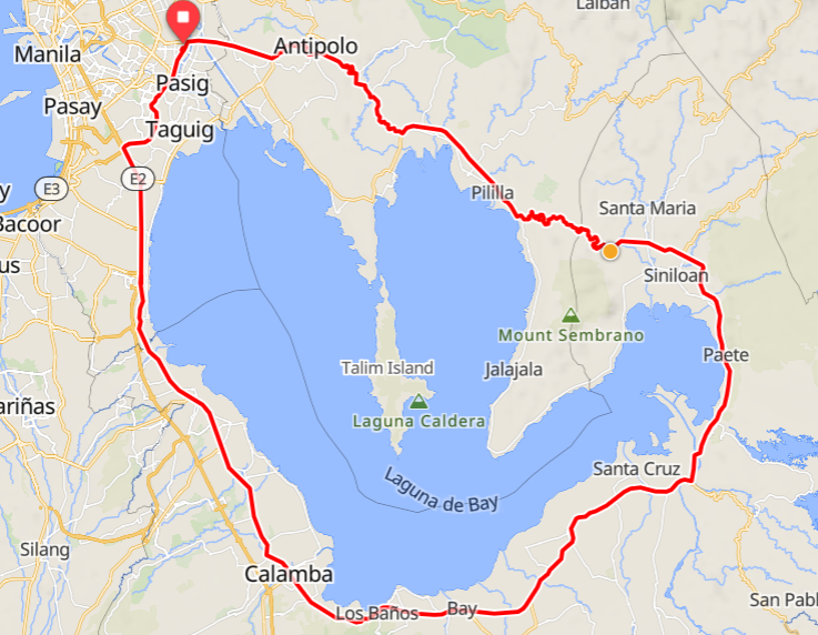 |
| The Laguna lake short loop skips the Jala-Jala peninsula Courtesy: ciclo.cc |
I took the longer route via the Mabitac-Pangil-Pakil road, along the lake's banks that includes a trip into the Jala-Jala peninsula.
|
| Laguna Lake complete loop Courtesy: ciclo.cc |
My 40 km ride within Jala-Jala was long drawn-out because of road repairs. Some parts of the road lanes are closed, allowing only 1 lane to pass at a time. The peninsula itself was uneventful, allowing just an occasional view of resorts and residential areas. In its center however, is Mt. Sembrano, drawing border between Laguna and Rizal, and provides one of the greatest views of Laguna lake.
 |
| Stopover at Brgy. Punta, Jala-Jala, Rizal |
I stopped at the tip of the peninsula in Brgy. Punta to take photos. Laguna lake looked serene in the afternoon sun. The western portion of the lake reveals Binangonan and other parts of Rizal that I will soon pass by.
I continued on and eventually completed the Jala-Jala passage. At around 4:30 PM, I was in Pililla, Rizal. The Mabitac-Pangil-Pakil road reconnects to the national road at this point.
 |
| Pililla, Rizal arch |
My ride through Tanay, Morong, and Binangonan took more time than I expected because of their busy town centers. These municipalities north of Laguna lake are gateways into the many tourist sites of Rizal that's why traffic converges into them.
 |
| Angono marker in front of the municipal hall |
Passing by Angono, the art capital of the country, was notable for me. I've never been here before but I'm interested in seeing the Blanco family museum and the street murals of national artist Botong Francisco. There's also the Angono-Binangonan petroglyphs site, known as the oldest artwork in the Philippines, just a few kilometers from the town proper.
* * *
It was 6 PM when I arrived in Taytay. The E-bank road in Manggahan floodway has a tendency for heavy traffic, especially in the intersection of Barkadahan bridge.
 |
| Barkadahan bridge in Taytay, Rizal |
This bridge is one of two bridges that connects Taytay to Pasig. It also gives access to C-6 road in Taguig, a 7 km express route leading to Bicutan, Parañaque.
 |
| C6 road in the north-west bank of Laguna lake |
Turning left at General Santos Ave. intersection in Taguig leads to Dir. A. Bunye. From here, it will be a straight ride, passing by the communities of Paranaque, until I arrive where I ultimately started in Alabang, Muntinlupa.
 |
| End of the ride at Starmall, Alabang |
I finished the ride at 7 PM, and it took me another 30 minutes to get home.
* * *
Riding through the Laguna lake loop was a great experience with its sights and the many places that it covers. It's a perfect course for a day ride and I would say, unintimidating even for beginner riders. The time spent on the road will be the only thing to watch out for, as fatigue can catch on in the latter parts of the ride. With proper pace, it will be an enjoyable and thrilling road trip, just like mine did.

Total ride time: 10 hours and 30 minutes.
Odometer before the ride: 12, 200 KM
Odometer after the ride: 12, 404 KM
Total KM: 204 KM
Comments
Post a Comment